FAQ
Frequently Asked Questions
If you have a question related to the Blanchard River watershed or any question related to watersheds, water quality, monitoring, etc., CONTACT US and we may include it here on our FAQ page.
What is the mission of the BRWP?
The Blanchard River Watershed Partnership seeks to address problems and concerns that affect the health of the Blanchard River watershed and educate all citizens to the dynamics of the Blanchard River and its tributaries.
What are the activities of the BRWP?
- Water Quality Monitoring
- River/Stream Clean-up
- Public Meetings to educate and hear concerns
- Exhibits at county fairs
- Support to community groups assisting the watershed like regional planning boards, parks, boards of health, soil & water conservation districts, etc.
- Educational Workshops
- Writing Non-Point Source Implementation Strategy (NPS-IS) Plans
- Monthly Board business meetings and various Committee meetings
- Work with farmers to promote Best Management Practices to protect the waterways
- Work with schools to educate students about environmental issues
- Coordinate with Federal, State and Local officials and agencies to promote policies aimed at protecting our waterways
How is the BRWP funded?
Funds are raised each year by the BWP for its annual budget from members and sponsors, and through grants from public and private groups. Recent grants from groups include The Findlay – Hancock County Community Foundation, the Great Lakes Commission and The River Network. All funds are approved by the Board of Directors and audited.
Does the BRWP have any authority of enforcement powers?
The BRWP can only encourage recommended actions, promote best management practices and suggest solutions and consequences to watershed issues. The BRWP has no special authority, powers or enforcement provisions within the Blanchard River watershed. The Partnership prefers to cooperate with landowners on long-term solutions and educating the public about their water quality.
Who runs the BRWP?
Volunteers govern the BRWP Board and Steering Committees. Board members are elected at the Annual Meeting to represent the various sub-watersheds and at-large members from various communities. See list of who’s who in the organization HERE. Interested individuals may express their interest to serve by coming to meetings or contacting the BRWP; others are recruited from areas of interest like, education, community water systems or citizen / professionals who can help further the MISSION. A “watershed coordinator” is also hired through grant funds as a local professional consultant to guide the BRWP with planning and activities.
What is a watershed?
A watershed is any area of land where surface water drains into a common body of water. If water from a neighborhood drains into a particular ditch, 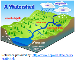 then that neighborhood shares a common watershed. Where ditches from several neighborhoods drain into a creek or brook, then all of those neighborhoods share a common watershed. Likewise, a watershed would include the geographical area of all creeks and brooks that drain into a river.
In our area of northwest Ohio, you might live within a watershed that is drained by Eagle creek or Riley creek or any number of other creeks. As those creeks empty into the Blanchard River, then you can say that you also live in the Blanchard River Watershed.
On a larger scale, you can claim that you live in the Maumee River watershed as the Blanchard flows into the Auglaize River, which then flows into the Maumee. Of course, the Maumee River flows into Lake Erie, which means that you are a part of the Great Lakes Watershed, too.
Interestingly, just a few hundred yards south of the headwaters of the Blanchard River in Kenton, Ohio, water flows to the Scioto River, which flows to the Ohio River and on to the Mississippi River and the Gulf of Mexico. So folks who live in the north end of Kenton have something in common with folks in Montreal, Canada, where water from the Great Lakes flows past on its way to the Gulf of St. Lawrence, while residents in the south part of Kenton have something in common with folks in New Orleans, near the mouth of the Mississippi River. Essentially, the quality of water in any watershed affects all living things within that watershed, no matter how large or small that watershed may be.
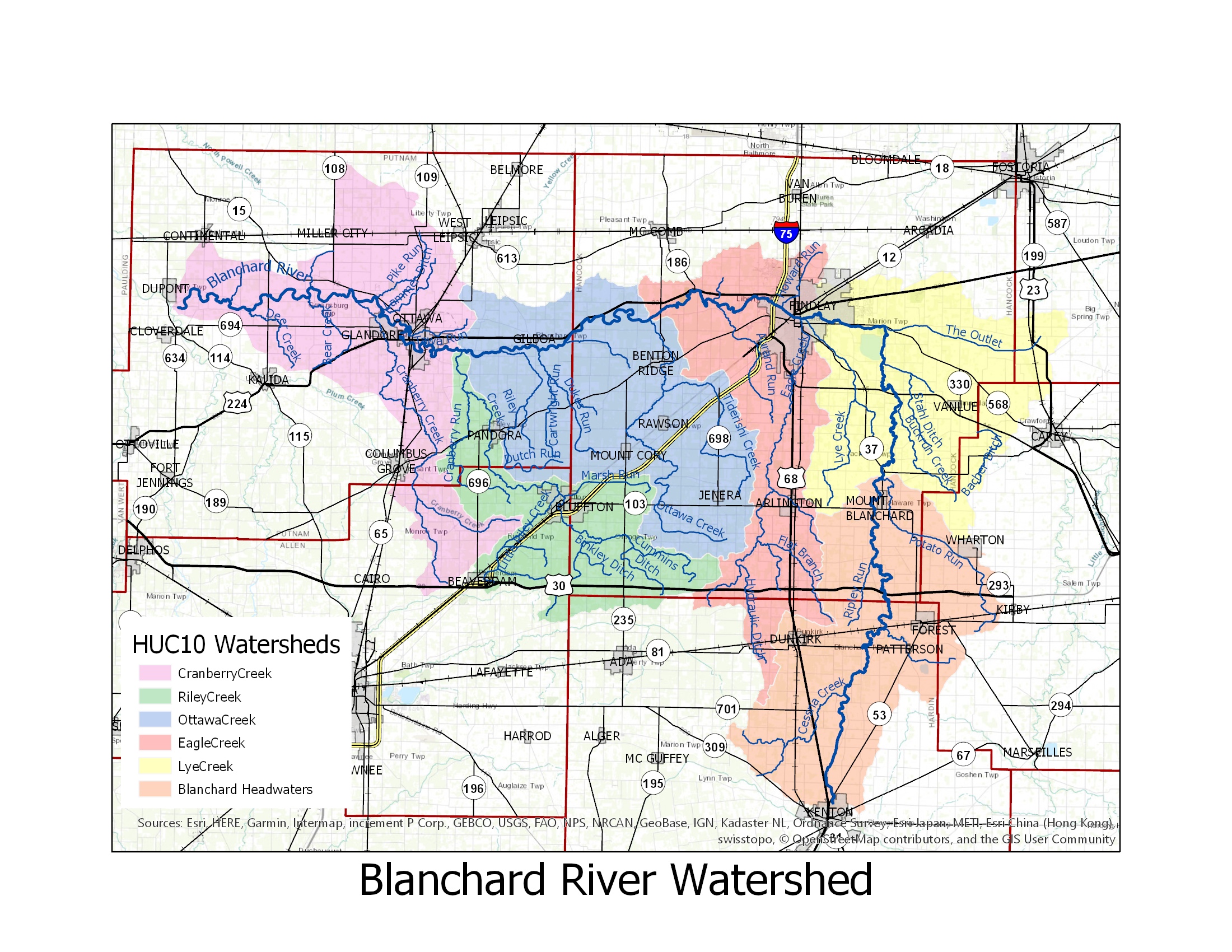
What watersheds affect the people of the Blanchard River Basin?
How much water is there when it rains?
According to an EPA report, three acre-feet of water is equal to one million gallons. An acre-foot is one acre of land covered by one foot deep in water. Three acre-feet describes the same area of land covered by three feet of water.
Acres of land in each sub-watershed:
Headwaters (010): 90,095 acres*
Lye Creek/The Outlet (020): 85,361 acres*
Eagle Creek (030): 73,601 acres*
Ottawa Creek (040): 95,286 acres
Riley Creek (050): 54,814 acres
Cranberry Creek (060): 94,258 acres
Total Acres: 493,415 acres
*The water from these three sub-watersheds flows through Findlay
Amount of water in a 4″,6″ or 8″ rain:
Four inches is 1/9th of three feet. If there are 1,000,000 gallons in 3 feet, then 1/9th of one million would mean there are 111,111 gallons of water. So, if there are 249,057 acres in the 3 sub watersheds that flow into Findlay, a four inch rain would result in approximately 27.67 billion gallons of water (assuming the ground is saturated).
Six inches is 1/6th of three feet. If there are 1,000,000 gallons in 3 feet, then 1/6th of one million would mean there are 167,000 gallons of water. So, if there are 249,057 acres in the 3 sub watersheds that flow into Findlay, a six inch rain would result in approximately 41.5 billion gallons of water (assuming the ground is saturated).
Eight inches is 2/9th of three feet. If there are 1,000,000 gallons in 3 feet, then 1/9th of one million would mean there are 222,222 gallons of water. So, if there are 249,057 acres in the 3 sub watersheds that flow into Findlay, an eight inch rain would result in approximately 55.34 billion gallons of water (assuming the ground is saturated).
The Blanchard River Watershed has two unique geological features:
- It is very flat over all.
- About 90% of the water flows north to the river before flowing west to the Auglaize River. This results in a greater amount of water needing to be carried by the river which leads to a wider area prone to flooding.
In addition, there is a 100 foot fall from the southern Hancock County line to Findlay. That is roughly 8 feet per mile which cause the flow out water from the south to be very fast. From Findlay west to the county line with Putnam County, the fall is only 10 feet or about 9 inches per mile. This results in the water piling up at Findlay and spreading out as it flows west.
What is an NPS-IS Plan?
A Non-Point Source Implementation Strategy (NPS-IS) Plan is a living strategic planning document that summarizes causes and sources of impairment, establishes critical areas, identifies quantifiable objectives to address causes and sources of impairment, and describes projects designed to meet those objectives.
For a project to be eligible for Ohio EPA Section 319 Funding, a proposed project must be described in a U.S. EPA-approved 9-Element NPS-IS for the HUC-12 watershed in which the project is located.
The NPS-IS ensures that potentially funded projects are: rooted in the best science available; located in areas that will address the worst problems; and that have the administrative, evaluation, and educational components needed to ensure that the water resource will achieve as much long term benefit as possible.
For more information visit the Ohio EPA website HERE.